
- Видео 16
- Просмотров 76 775
GIS Tips and Tricks
Индия
Добавлен 8 ноя 2020
Master GIS with easy-to-follow GIS tips and tricks! This channel is your one-stop shop for learning everything from basic mapping to advanced spatial analysis in ArcGIS, ArcGIS Pro, Q GIS, Erdas Imagine, MapInfo, PCI Geomatica, Envi, and Google Earth Pro. Whether you're a beginner or a seasoned pro, you'll find valuable tutorials, troubleshooting guides, and time-saving hacks to boost your GIS skills. Subscribe for new videos every Sunday!
Share, Support & subscribe…….
Share, Support & subscribe…….
How to Download the Shapefile of India with Jammu and Kashmir- Step by Step Guide | Survey of India
In this video, you will learn how to download the administrative boundary shapefile of India for free. Follow our step-by-step guide to get access to this valuable data source effortlessly. Basically in this tutorial, I have downloaded this data from a survey of India's official website. Here you can see the administrative boundary of India with Jammu and Kashmir and Ladakh.
Survey of India official website link: surveyofindia.gov.in/
Timecodes
00:00 - Intro
00:59 - Account creation in the SOI portal
04:28 - User profile udation
07:08 - Data import in ArcMap
#IndiaAdministrativeBoundary #ShapefileDownload #FreeGISData #IndiaMaps #DataDownload #GeospatialTutorial #GeospatialData #DataAnalysis #GI...
Просмотров: 186
Видео


🌟 Ultimate Guide for Installing QGIS Like a Pro! | How to install QGIS
Просмотров 543 месяца назад
🌟 Ultimate Guide for Installing QGIS Like a Pro! | How to install QGIS QGIS is a free and powerful Geographic Information System (GIS) that lets you analyze, edit, and visualize geospatial data. In this video, we walk you through the step-by-step process of installing QGIS on your Windows PC, getting you ready to unlock the world of GIS! Whether you're a beginner or a seasoned geographer, this ...

automatically Building Footprint digitization in qgis|MapFlow| how to Auto digitize in qgis|gtt
Просмотров 13 тыс.2 года назад
Hello viewer, welcome to my channel gis tips and tricks or gtt. Today I have shown the automatic building’s footprint digitization process in this tutorial or tricks stapes by stapes. Here I’m using MapFlow plugins for automatic digitization. Mapflow plugins have artificial intelligence or API which digitizes an area automatically. I have elaborated this tutorial in 4 parts. This is the most po...

Georeferencing in ArcMap or ArcGis tutorial| toposheet rectify in arcgis | pdf map to jpg conversion
Просмотров 8752 года назад
Hi friends, today in this video I show you how to georeferenced a scanned map in ArcGis software. Here I will describe it through two step, first I will show you how to convert a pdf map to in a jpg format. And the second step I will show to you how to do georeferenced in ArcMaps. if you don’t know about the how to download toposheet totally free then check this video: 1. How to download toposh...

How to download toposheet free from survey of India || full steps of download soi toposheets | GTT
Просмотров 1,5 тыс.2 года назад
In this video we want to know about how to download toposheet or topographical maps from survey of India. Here first we learn about account creation in survey of India website for toposheet download and the second we learn about how to download the toposheet. All downloaded toposheet is free and available in pdf format with 1:50,000 scale. All the toposheet are totally free. Important Links of ...

how to install QGIS in Linux or Ubuntu pc || full QGIS installation || QGIS || Linux | ubuntu 22.04
Просмотров 9 тыс.2 года назад
Friends today in this video i will show how to install qgis in Linux and ubuntu pc. qgis is open source free software for gis professional. here I'm using 3.26 version of qgis. Here I'm using ubuntu 22.04 version. official site of qgis: www.qgis.org/ Our aim to prepare everyone for the skill of today and tomorrow. This channel provides best knowledge of GIS Technology with easy way. Subscribe t...

how to install google earth pro on pc | How to use google earth pro | google earth | google maps
Просмотров 7782 года назад
Hello friends, google is the no 1 search engine in world. Google earth pro is one of the best software for using google satellite date. in my channel GIS Tips and Tri i am showing you how to install or download google earth pro and I'm also try to elaborate how to use google earth pro. google maps widely used in the world, google earth pro is best option for using gmaps data. #google #googleear...
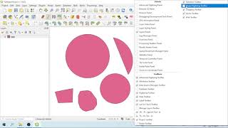
how to create a proper circle and rectangle in QGIS| Shape Digitizing Toolbar in QGIS| #qgis #arcgis
Просмотров 27 тыс.2 года назад
hi friends through this video I have shown how to draw a proper circle or rectangle in qgis. for doing this work you may use shape digitizing toolbar in qgis.

How to export KML with label in ArcGIS| KML export
Просмотров 22 тыс.3 года назад
GIS tips and tricks is the source for learning everything related to Remote Sensing GIS (Geographical Information System) Satellite Imaging Technology, Visual interpretation of Various Satellite & Ortho Images, Cartography and We also Share tutorial of different GIS Software like ArcGIS, ArcGIS Pro, Qgis, Erdas Imagine, MapInfo, PCI Geomatica and much more. Our aim to prepare everyone for the s...
Upgrade ERDAS IMAGINE 14 to ERDAS Classic: Step-by-Step Guide | erdas imagine | gis tips and tricks
Просмотров 1063 года назад
📌 Learn How to Upgrade ERDAS IMAGINE 14 to ERDAS Classic Effortlessly! 📌 Welcome to our comprehensive guide on upgrading ERDAS IMAGINE 14 to ERDAS Classic! This step-by-step tutorial is perfect for both new and experienced users looking to seamlessly transition to the classic version. In this video, we’ll walk you through the entire process, ensuring you make the most of ERDAS Classic's advance...
How to download any shapefile all over the world|Diva GIS|free shapefile download| gis tips & tricks
Просмотров 8973 года назад
today in this video I show you how to download free shapefile all over the world with Diva gis website.
How to create centroid in arcgis | arcmap | what is centroid | ArcGIS tips |ArcGIS tricks| centroid
Просмотров 7273 года назад
hello viewer today I show you how create centroid in arcgis.
how to download satellite image||satellite data download from usgs||satellite image download tricks.
Просмотров 3703 года назад
hi friends to day in this video i gonna show you how to download high resolution satellite image from usgs earth explorer. through earth explorer you can download different datasets like land set, sentinel, hyperian different dem image or elevation model also.
how to add google image in Qgis 3.12||how to add google tiles in qgis||qgis tips and tricks. google
Просмотров 4663 года назад
hello guys today in this video I show you how add google tiles in qgis 3.12. important map- link OpenTopoMap- tile.opentopomap.org/{z}/{x}/{y}.png OpenStreetMap- tile.openstreetmap.org/{z}/{x}/{y}.png Google Hybrid- mt1.google.com/vt/lyrs=y&x={x}&y={y}&z={z} Google Satellite- mt1.google.com/vt/lyrs=s&x={x}&y={y}&z={z} Google Road- mt1.google.com/vt/lyrs=m&x={x}&y={y}&z={z} Bing Aerial- ecn.t3.t...
How to create a shapefile in ArcGIS | ArcMap | shp file creation | gis tips and tricks
Просмотров 1163 года назад
📌 Learn How to Create a Shapefile in ArcGIS Easily! 📌 Welcome to our comprehensive guide on creating shapefiles in ArcGIS! Whether you're a GIS beginner or an experienced user looking to refresh your skills, this step-by-step tutorial is perfect for you. In this video, we'll cover everything you need to know to create, customize, and manage shapefiles in ArcGIS. 🗺️ In This Video, You'll Learn: ...
how to add select feature tools in arc map 10 4 Tricks of add select feature
Просмотров 463 года назад
how to add select feature tools in arc map 10 4 Tricks of add select feature
Daphnee Fork
thank you, very useful with simple explanation
Thank you so much! I'm a windows user and it was confusing for me
Hi.. how to make home polygon like that quickly? Is there tutor?
how to count the houses in the labelled area ? need help urgent
Thank you sir 🙏
anybody here who tell me the name of third toolbar
1. Lat long tools toolbar- you can add it from plugins 2. Data source manager toolbar 3. Digitising toolbar 4. Mapflow plugins
what is name of third tool bar please tell me sir
Tool - Mapflow.
Thank you
Thank you so much 😊
Thanks for explaining how to create the circle. To improve, it would've been useful to show how the circle dimension is determined, as we don't want to create random shapes, but to set them to a specific dimension, say in metres diameter for a circle, or metres Length and Width for a circle?
Hola, sé hacerlo pero no que no sé ahora es cómo salir de ahí, no puedo dibujar lo que quiero, se me quedó en una forma regular y no hay manera
Wow, such a brilliant idea
Thank you! 😊
its just 25sqkm limit
yes, it has some limitations.
hello, sir i need job. i have work experience in qgis field around 2 years. please reply me ....
Hello, if have file Orthophoto Map. Can do it?
yes, you can do it but the final output come as per the mapbox image.
WHAT HAPPEN TO YOUR VOICE? IT NEVER COME OUT FROM YOUR MOUTH... I CAN'T HEAR IT...
Apology.. next time I will improve it. Thanks for your suggestion.
please SPeak UP
Apology.. next time I will improve it. Thanks for your suggestion.
Thank you very much.... extremely helpful for the beginners in Linux interface
Thankm you very much for your help!
your english is terrible
Thank you very much for help. It is helpful guide. With regards from Slovakia :)
please the third bar what is the name of it
1. Lat long tools toolbar- you can add it from plugins 2. Data source manager toolbar 3. Digitising toolbar 4. Mapflow plugins
thx it was very usefull
Thank you for this video from the Mapflow team! Welcome to try our upgraded models.
Thanks to mapflow team. I am happy to try the upgraed models.
Thank you so much
Is this free?
The Plugin is free with some limitations on area processing size.
Are samples of it entered in the study area, or is there a library with different types of buildings?
Thanks sir, can i use this maptools for Indonesian Maps for classify buildings?
Yes you can.
Very good video with useful command
After using the digiting Shape Tool, How to go with the default polygon feature?
after using this tool you have select the "add polygon" tool for create default polygon feature.
@@GISTipsandTricks can you show us how to do it, cause I think I did click the "add polygon" tool but its still not on the default polygon feature
Awesome thank you 🙏
How we can download it with yearwise
Here you can download only archive maps. At this time year wise function is not add in this website.
it seems like processing limit is decrease, what to do if the processing limit is already exceed
Here processing limit is only 50 acer area. But if the limit is exceed then you need an another account to get another 50 acer processing area. Use a temporary mail for unlimited account.
Simply ask us about more credits or sq kilometers for your project :)
digiting video useful...nice work
Many many thanks
this video very useful....
Thank You
nice video and amazing..
Thank you
This was very helpful to me (chromebook user completely unfamiliar with linux), thank you.
Welcome, Please stay connected for more informative videos.
Pls make video how to convert kml to shp File without losing attribute
Stay connected with us. We will make a video on this if possible.
Good 👍
GREAT VIDEO
Good video
I am looking for rodrigues island what should i do if the country dont figure in the list.
আরে দাদা ফাটাফাটি
Very good video
Weldone