
- Видео 83
- Просмотров 34 330
Charlie's Hikes
США
Добавлен 13 май 2019
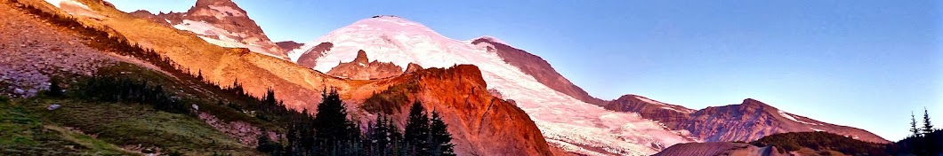
Maah Daah Trail Day Four: Medora, ND to Short Road
This is the fourth in a series of sequenced hikes on the Maah Daah Hey Trail going from south to north. Views include badlands, prairies, buttes, and fall colors.
Просмотров: 93
Видео


Maah Daah Hey Trail Day Three: Mile 41.5 to Medora, ND
Просмотров 1472 месяца назад
This is the third in a series of sequenced hikes on the Maah Daah Hey Trail going from south to north. Views include badlands, prairies, buttes, and fall colors.

Maah Daah Hey Trail Day Two: Near 48th Street to Mile 41.5
Просмотров 932 месяца назад
This is the second in a series of sequenced hikes on the Maah Daah Hey Trail going from south to north. Views include badlands, prairies, buttes, and fall colors.

Maah Daah Hey Trail Day One: Burning Coal Vein to Near 48th Street
Просмотров 1433 месяца назад
This is the first in a series of sequenced hikes on the Maah Daah Hey Trail going from south to north. Views include badlands, prairies, buttes, fall colors, and the Little Missouri River.

Georgia: Lamazgora Ridge, Vani Municipality
Просмотров 1884 месяца назад
I hiked a ridge below Mount Lamazgora (7,142 feet) in the Vani Municipality of the Republic of Georgia. Views include meadows, forests, snowfields, flowers, cabins, and some amazing clouds. This hike requires access to the ridge via a rugged jeep road. I traveled there with some friends from the Vani Municipality. Here is more on the Vani Municipality and the area: en.wikipedia.org/wiki/Vani_Mu...

Georgia: Cross Above Mestia
Просмотров 325 месяцев назад
I hiked to the cross above Mestia in the Republic of Georgia. This hike starts in the town of Mestia and climbs aggressively up the ridge above it. Views include city, mountain, forest, valley, meadow, cows, and pigs. Here is more information on the hike and Mestia: transcaucasiantrail.org/en/hike/upper-svaneti-georgia/day-hikes-from-mestia/#cross-over-mestia en.wikipedia.org/wiki/Mestia

Georgia: Chubedishi Ridge
Просмотров 515 месяцев назад
I hiked up the ridge that leads to the top of Mount Chubedishi, just outside of Ushguli in the Republic of Georgia. This the second of two hikes that I did with Max Thompson in the Ushguli area. Views include mountains, glaciers, rivers, city (Ushguli), meadows, and snow fields. Here is more information regarding the hike and Ushguli: www.caucasus-trekking.com/treks/ushguli-to-chubedishi en.wik...

Georgia: Shkhara Glacier
Просмотров 1845 месяцев назад
I hiked to Shkhara Glacier, at the base of Mount Shkhara, the highest point in the Republic of Georgia (17,070 ft), along with Max Thompson. We hiked out and back from Ushguli, Georgia. This hike takes place in the Upper Svaneti Region, which is recognized as a UNESCO World Heritage Site. Views include mountains, meadows, rivers, streams, the glacier, cows, horses, dogs, and some bonus footage ...

Azerbaijan: Shah Spit, Absheron National Park
Просмотров 436 месяцев назад
I hiked the Shah Spit in Azerbaijan's Absheron National Park. This is a beach walk with views of the Caspian Sea and some beautiful cloud formations. The end point is at the tip of the peninsula, the furthest east point of mainland Azerbaijan. It is known as the tip of the beak as Azerbaijan is shaped like a bird. Here is more information on the spit: en.wikipedia.org/wiki/Shah_Spit
Slovakia SNP Trail 3: Prezinska Baba to Smolenice Castle
Просмотров 916 месяцев назад
This day I hiked from Prezinska Baba to Smolenice Castle, mostly on the SNP Trail in Slovakia. It was the third and final day of consecutive hikes that followed the SNP Trail. This hike topped two of the three highest peaks in the Little Carpathian Mountains and was my biggest elevation gain (over 6,000 feet) and loss (over 7,000 feet) hike of all time. Views include forests, meadows, streams, ...
Slovakia SNP Trail 2: Kamzik TV Tower to Prezinska Baba
Просмотров 707 месяцев назад
This was a hike on the SNP national trail in Slovakia from Kamzik TV Tower in Bratislava to the Prezinska Baba ski area. It includes forest, mountain, meadow, creek, and swamp views. Here is more information on the SNP Trail: snptrail.com/ I am pretty sure that the snake that I saw on this day was a Aesculapian Snake. It is non venomous. Here is more information on it: en.wikipedia.org/wiki/Aes...
Slovakia SNP Trail 1: Devin Castle to Kamzik TV Tower
Просмотров 597 месяцев назад
This hike begins at Devin Castle, in Devin, Slovakia. Following the SNP national trail across Slovakia, It then transitions to a hike through Bratislava, Slovakia, ending at Kamzik TV Tower above the city. The hike includes forest views, views from an observation tower, an old Soviet base, and landmarks like the Kamzik TV Tower and Devin Castle.
Chanterelle Trail Loop
Просмотров 898 месяцев назад
I hiked a loop in Lake Whatcom Park involving the Hertz Trail, Chanterelle Trail Connector, and Chanterelle Trail. Views include lake, forest, waterfall, creek and mountain. Lake Whatcom Park is located near Bellingham, Washington.
Mount Constitution
Просмотров 2018 месяцев назад
I climbed Mount Constitution, a mountain located in Moran State Park on Orcas Island in Washington State. Views include forest, Puget Sound, lakes, creeks and mountains.
Sugarloaf Mountain and Mount Erie
Просмотров 1009 месяцев назад
This hike took place in Anacortes, Washington, in the Anacortes Community Forest Lands. Views include mountain, water, islands, and forest.
Hart's Pass - Slate Peak, Barron Yurt, and Fall Colors
Просмотров 145Год назад
Hart's Pass - Slate Peak, Barron Yurt, and Fall Colors
PCT Day 2 SOBO 2023: Mile 8.2 to Hart's Pass
Просмотров 116Год назад
PCT Day 2 SOBO 2023: Mile 8.2 to Hart's Pass
PCT Day 1 SOBO 2023: Hopkins Lake to Northern Terminus to Mile 8.2
Просмотров 74Год назад
PCT Day 1 SOBO 2023: Hopkins Lake to Northern Terminus to Mile 8.2
Tahoe Rim Trail: Star Lake to Spooner Summit Trailhead
Просмотров 452Год назад
Tahoe Rim Trail: Star Lake to Spooner Summit Trailhead
Tahoe Rim Trail 2023 Gear List, 12 lbs, 6 oz base weight
Просмотров 2,9 тыс.Год назад
Tahoe Rim Trail 2023 Gear List, 12 lbs, 6 oz base weight
2023 Ouachita Trail Day 4 - Queen Wilhelmina Lodge to Foran Gap
Просмотров 212Год назад
2023 Ouachita Trail Day 4 - Queen Wilhelmina Lodge to Foran Gap
2023 Ouachita Trail Day 3 - Pashubbe Shelter to Queen Wilhelmina Lodge
Просмотров 225Год назад
2023 Ouachita Trail Day 3 - Pashubbe Shelter to Queen Wilhelmina Lodge
2023 Ouachita Trail Day 2 - Holson Valley Shelter to Pashubbe Shelter
Просмотров 153Год назад
2023 Ouachita Trail Day 2 - Holson Valley Shelter to Pashubbe Shelter
2023 Ouachita Trail Day 1 - Talimena State Park to Holson Valley Shelter
Просмотров 380Год назад
2023 Ouachita Trail Day 1 - Talimena State Park to Holson Valley Shelter
It's hard to see on the video but were you able to pinpoint Vancouver from the top view?
We did the cross country up the ridge from marmot pass to charlia lake back in the 80s.
I was up at Frog Lake on Carson Pass in 2017. Had bug juice all over me. I keep hearing thousands of little wings but couldn't see them. I look above me and 3 ft up is nothing but micro vampires trying to figure a way to land. Made for an interesting photo.
22 mile hike with and extra mile for camera retrieval. I hiked this trail a couple of times but never made it to the ranch. I was sure you would have some pictures of the tree with the rock engulfed in its trunk. Too bad they haven't fixed that road yet. Trails need maintenance. Thanks for sharing.
I appreciate your sharing the beautiful scenic photography of your strenuous trek, though I had to silence the music that clashed with the serene solitude of the East Tonto Trail. I will look for your later videos with a different style.
Thanks for sharing your experience.
Planning this any recommendations???
It is quite rocky and can be slippery, so be prepared for that element. Bring gloves for handling the rope sections. Know the tide schedules as certain areas will be impassable when the tides are high. Bring clothing for all conditions. The coast tends to get more rain than the rest of the state. Have a great hike! It is a really peaceful experience being out on the coast.
GJ for the easiest part of the SNP trail .
Great video!
Ah yes, Mtn Goats going from urine spot to urine spot... Whole herd of them over by Kool Aid Lake and its a thunderous rush to anyone who dares take a leak.
Indeed
Thanks Charlie for sharing this! Keep 'em coming😃
Chanterelles yummy!…beautiful place
Thanks Mike
That was a nice looking trail. Awesome view! A great hike my friend.
Thanks Jim
interesting route here!
Really incredible views from the summit. Loved the views and the trail to the summit. Great share, Charlie!
You like music when you hike? Please let's hear the sounds of nature when you post the vid. THX
I've changed my style since this video. You will hear primarily nature these days.
I saw Sammy for a split second, haha :) It was such a fun day!
beautiful area!
Very nice scenery. Thanks, Charlie.
aren't Bear Vault required?
Required for Desolation Wilderness and strongly recommend by the TRTA for the whole trail.
Thanks for your TRT video. Really enjoyed your style of vlogging. Beautiful scenery and insightful dialogue. Safety first. Embrace the Alternate (on trail and in life). Peace and happy trails.
Can you post the list of gear in the description?
Thanks for the feedback Jessica. I'll post a gear list the next time I do one of these.
The view 10 The music 0
Music is always a tough judgement call on these videos. I'm glad that you enjoyed the view.
Thanks for sharing. I am planning a late Feb. into Early Mar. hike of the OT, I’ll be watching the remainder of your OT videos.
Have a great hike!
Man, you are a beast. When you first mentioned Rich Roll, and about the third day of your trip with so many miles, I was thinking, this guy must be doing plant based or something. I switched back in September and a few weeks later, went to Silver Lakes via Mt. Townsend. The improvement in my endurance was staggering. Much different than my Elwha trip at the beginning of July, a month after surgery. My legs cramped up pretty bad on that trip before Whiskey Bend. I’ve had so much improvement that I really feel no temptation to go back. On that note (if you are still doing the plant based thing), check out Harmony House Foods and Leafside, if you haven’t already. I use a Hydropeak food jar. Just pour in however much you feel like eating, add boiling water, and put the lid on. Did a 45 minute walk down to Buckhorn Lake from camp and the food was still so hot I had to blow in each bite. None of that cooled off and still crunchy nonsense one can get with just the pouch meals.
Thanks for your comment. I continue to be plant-based. It will be 6 years this August. It was an amazing transformation for me and I don't plan to go back either. I will check out your recommendations.
Breathtaking! Thanks for taking me home. I grew up and lived in Wenatchee/Chelan for most of my life. I miss it! Watching this was sweet nostalgia. Thank you for sharing!
Great video ! I don’t know how you accomplish the yellow trail tracer thingy but it is awesome. It adds such an interesting perspective. Keep up the good work.
I am using an app called Relive.
You’ve had blister problems on previous hikes? Any idea what the long term solution is to them?
I've had them before. I'm pretty sure the Ouachita situation was shoes that did not fit well enough, in addition to more rocky terrain than I'm used to hiking and wet feet from the river crossings. I've been focused more on my feet since, doing a variety of things to help their health. Some things I've been doing include changing out socks more frequently, cleaning my feet at the end of a hiking day, soaking my feet in a stream or two during a hike, and pre-applying leukotape to areas that are blister prone. They've done better of late.
難以置信,大背包內,大大小小的防水袋,防水膠袋,約有20個。減少防水袋,可減輕1 lb,可增加食物🤣
Really enjoyed your gear list, you mentioned your video was recorded on a Diji Osmo Pocket. Is it the version 1 or 2, I ask this because the quality was very impressive for such a light wt, flog camera. Thanks in advance, have a great hike….
Thank you - my camera is an Osmo Pocket 1.
Very nice and misty! On my list! Thx for sharing!
Depending on when/where you’ll be you might not have much snow! I’ve been doing some big sections of it to prep for the Jmt in a couple weeks and the snow has been very easy to manage.
Loved this! I was mesmerized. Thanks for sharing the challenges--I learned a lot! -Rob
Good job.
Great videos Charlie, really well done. We have subscribed in support! We know how hard it can be to produce good content and get your RUclips off the ground. We're a small channel too and going through it ourselves. So really wanted to show our support. Keep up the good work! Wish you success
What is the name of the sleep apnea mouth device? I use a big CPAP that would never be taken on a hike.
My appliance is called SomnoDent Avant, made by a company called SomnoMed. I started with sleep doctor and she referred me to a specialist dentist who makes these devices. At least for my insurance, I either had to either replace my CPAP with a mouth device, or I had to pay out of pocket to receive one. I did the latter as my CPAP works well otherwise. As an alternative, some of the newer travel CPAPs are very small and I have seen at least one video where someone planning to take one out backpacking: ruclips.net/video/BRBG2IMXYtw/видео.html. She'll likely have updates in future videos.
Nice gear set up!
Thanks Charlie!
Great video! Thanks for posting. Helpful for someone preparing for the trail!
1:00 I made the exact same wrong turn yesterday. Only I realized it as soon as the bridge came into view and thus turned around before I got the view. I made the wrong turn because the sign pointing to Whiskey Bend was damaged.
I am sorry that happened to you as well. Hopefully they will fix the sign at some point.
Awesome trip! Thanks for producing this video
This actually looks like a good one! Didn't really know that much about Gray Wolf until I did a trail work party on the lower GW. Thanks!
Love the video! Enjoyed meeting you too. Hope you come back soon!
Thanks Dale, I enjoyed meeting you too and really appreciated the ride. I am planning to come back next winter. You inspired me to start running again so thank you for that as well.
I grew up there.
Woww...looks like an awesome place to hike and camp..it may be a future trip to go to to camp and hike ..every once in awhile I leave the swamps of Florida to head to mountains..great video!
It is a good area. I definitely recommend it and have plans to go back.
It looks like a phone on your shoulder, and you are filming so 2 phones?
I am filming with a DJI Osmo Pocket. It is a very small 4 once camera with a gimbal that shoots in 4k. It is not waterproof. On occasion I use my phone, especially around water.
Count me inn I love hiking
Awesome
keep hiking on!
Thanks Charlie for documenting this adventure on video. So fun!