
- Видео 6
- Просмотров 129 759
GIS Solutions
Пакистан
Добавлен 13 мар 2017
GIS Solutions has been founded as a channel on RUclips to provide free and easy-to-understand tutorials of ArcGIS. ArcGIS 10.7 is the latest version of ESRI corporation till date. GIS is a must to use tool if you handle large data in day to day professional life. GIS not only helps you to easily analyze the data but also evaluate important conclusions from the information. Whether you are an engineer, doctor, businessman or you belong to any other profession, GIS is just the right tool for everyone, leading to successful decisions.
Buffer Analysis in ArcGIS
Buffer Analysis is explained with a practical example using ArcGIS 10.5. Multi Ring Buffer Analysis has also been explained in addition to it. Don't Forget to Subscribe to GIS Solutions to continue learning.
Просмотров: 7 395
Видео


How to add Basemap from ArcGIS Online and Working with them in ArcMap
Просмотров 8 тыс.7 лет назад
ArcGIS tutorial - Adding Basemap to ArcGIS and Working with them. Don't Forget to subscribe to GIS Solutions to keep learning ArcGIS.
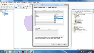
Attribute table and Data Types in ArcMap
Просмотров 8 тыс.7 лет назад
A tutorial of ArcGIS -Working with attribute table e.g. adding fields to the attribute table and adding data to it. Data Types in ArcGIS is also clearly explained. Don't Forget to subscribe to GIS Solutions to keep learning ArcGIS.
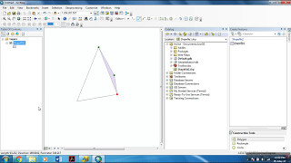
Creating / Editing Shapefiles in ArcMap
Просмотров 89 тыс.7 лет назад
A tutorial of ArcGIS 10.5 -Creating and editing shapefiles in ArcMap 10.5. Don't Forget to subscribe to GIS Solutions to keep learning ArcGIS.

Creating Geodatabase and Adding Feature Class in Arcmap
Просмотров 10 тыс.7 лет назад
A tutorial of ArcGIS 10.5 -Creating Geodatabase and adding feature class to it in ArcMap 10.5. Don't Forget to subscribe to GIS Solutions to keep learning ArcGIS.

Introduction to ArcGIS 10.5 Get Started in 5 minutes
Просмотров 6 тыс.7 лет назад
Don't forget to subscribe to GIS Solutions to stay updated with the ArcGIS 10.5. Basic Introduction to ArcGIS 10.5 to help you get started in few minutes so that you can pursue further tutorials. This tutorial is intended to give you an idea of the interface of ArcGIS. It is must to learn this tutorial and its succeeding tutorials to have a better understanding of the software.
how could i digitize it after saving it from basemap ?
I tried many times but error occur in start editing... When I click on editing option than it can't be opened give different type of errors
openstreetmap does not show in my basemap directory
thanks bro you saved me
thank u so much, u go directly to the point, a very useful video.
PAKISTAN ZINDABAD
you are doing an excellent job please continue to guide people
Thank you
Base map is disabled sir what is the option
This problem is occuring with ArcGIS 10.1. Try using latest version of ArcGIS.
Hi. Excuse Me, I have a question. I would be so thankful if you answer that. I have saved all of my GIS files in a folder on my desktop. Now, I want to organize them and change their location from my computer to my external ram. But the files do not work there. Sounds like it cannot read different layers because of the change in their direction. Do you know how I can do that? Obviously, I cannot keep them on my desktop forever :)
Thanks and shall I get some more videos on editing of shape files please.
i try it too but there were an x mark amd the map didn't appear. How sad :(
Try downloading the base map again from ArcGIS online.
Nice
Welcome to ArcGIS Tutorial My channel can help you also if you want ruclips.net/channel/UCRAq9-MSHJcNbU4SZ8orjPQ?view_as=subscriber
Welcome to ArcGIS Tutorial Nice Video, Helpful as well. My channel can help you also if you want ruclips.net/channel/UCRAq9-MSHJcNbU4SZ8orjPQ?view_as=subscriber
This helped me a lot, thanks!
Glad to hear it!
Bhi het map k bary me b video bnao
Thank you!
You're welcome!
Reallly good
Thanks!
this was really excellent.... tanx
You are welcome!
Hi! Brother I have problem when Convert Coor_system from Indian_Thailand to WGS84 on Arc Tool box of Arcmap 10.5
too much extra noise is there in video
Mate, this was sooooo usefull saved my life
Thanks!
yaaaaaaaaaaaaaaaaaaaaaaaaaaaaaaaaaaaaaaaaaaaaaaaaaaaay
how to fix add data from Arcgis online show in Arcmap
thank you brother it's nice
you are most welcome bro! <3 (Dont forget to Subscribe the channel as I am planning to make new GIS tutorials covering advanced topics.)
Which basic geometrical objects exist and which file format are they stored in ESRI?
Good job bro!I follow all of your videos!Cheers
Thank you for the appreciation.
good!
Thank you